Facts about Latitude and Longitude
Facts about Latitude and Longitude
Any location on Earth is described by two numbers-its latitude and its longitude. If a pilot or a ship's captain wants to specify position on a map, these are the"coordinates" they would use.
Actually, these are two angles, measured in degrees, "minutes of arc" and "seconds of arc." These are denoted by the symbols ( °, ', " ) e.g. 35° 43' 9" means an angle of 35 degrees, 43 minutes and 9 seconds (do not confuse this with the notation (', ") for feet and inches!). A degree contains 60 minutes of arc and a minute contains 60 seconds of arc and you may omit the words "of arc" where the context makes it absolutely clear that these are not units of time.
Latitude
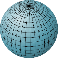
On a globe of the Earth, lines of latitude are circles of different size. The longest is the equator, whose latitude is zero, while at the poles--at latitudes 90° north and 90° south (or -90°) the circles shrink to a point.
Longitude
On the globe, lines of constant longitude ("meridians") extend from pole to pole, like the segment boundaries on a peeled orange.A lines of longitude is also called a meridian, derived from the Latin, from meri, a variation of "medius" which denotes "middle", and diem, meaning "day." The word once meant "noon", and times of the day before noon were known as "ante meridian", while times .after it were "post meridian." Today's abbreviations a.m. and p.m. come from these terms, and the Sun at noon was said to be "passing meridian". All points on the same line of longitude experienced noon (and any other hour) at the same time and were therefore said to be on the same "meridian line", which became "meridian" for short
1. Latitude lines circle the globe in an east-west direction. Latitude measure show far north or south a point lies from the equator. (Latitude lines are also called parallels, as they are parallel to the equator.)
2. The equator is at 0° latitude and separates Earth’s Northern and Southern hemispheres.
3. Locations north of the equator have latitudes between 0° (theequator) and 90° N (the North Pole).
4. Locations south of the equator have latitudes between 0° (the equator) and 90° S (theSouthPole).
5. Longitude lines run from the North Pole to the South Pole.
6. Longitude measure show far east or west a point on Earth lies from the prime meridian. (Longitude lines are also called meridians.) .
7. The prime meridian,the line of longitude that passes through Greenwich ,England, is the 0° longitude line.
8. Longitude values to the east of the prime meridian can be specified by 0° to 180°E or by positive values 0° to +180°.
9. Longitude values to the west of the prime meridian can be specified by 0° to 180°W or by negative values 0° to -180°.


Comments
Post a Comment